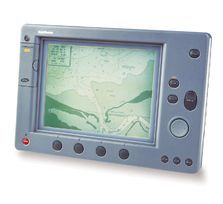
Raychart 620 Chartplotter
Dunmast also offers the popular selling Raychart 620. Its 10" supertwist LCD screen delivers crisp pixels resolution auto compensating to maintain readability even in bright sunlight. Four levels of grey scale are used to communicate water and land mass detail giving you the perfect view of your cruising environment in 3 dimensional detail.
Large
Memory Capacity
You can store up to 1,000 waypoints/events, 1,000 marks
and 5,000 trackpoints, and save tracks and marks to a
memory cartridge. Data stored includes a 16 character
alphanumeric name, position, date and time. Active route
information is shared between the Raychart 620 and other
units on the Raytheon Sea Talk bus.
Detailed Charting
including New Tidal Heights and Port Information
Whether in colour or greyscale, chart presentation can be
as detailed or as uncluttered as you like. Chart
boundaries, names, coastal features, restrictions, depth
contours and spot soundings can be switched on or off. An
outstanding new feature for 1998 both plotters have
extended capability to display tidal and port information
data at the push of a button.
Full integration
capability
The Raychart 620 integrates easily and powerfully with
your SeaTalk instruments and autopilot. Data boxes (fully
configurable by you) bring vital performance, autopilot
and alarm information to your Raychart screen.
Additionally both plotters provide simultaneous NMEA and
Sea Talk interfacing with the option for manual
differential beacon set up.
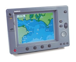
Raychart 630 Chartplotter
| Display | |
| Display Type | 10" TFT LCD 64 colours, backlit (not suitable for external mounting) |
| Resolution | 640 x 480, Landscape |
| Dimensions | 12.8' x 8.4Ó x 1.5' (325 x 213 x 38mm) |
| Waterproof | U.S.C.G. CFR-46 Standard |
| EMC | EN 60945 |
| Interfaces | SeaTalk in/out, NMEA out, NMEA GPS in |
| Controls | 8 defined keys, 4 soft keys, and trackpad |
| Cursor | Provides range and bearing or Lat/Lon |
| Cursor Echo | Cursor echo between radar and chart displays connected via SeaTalk |
| Repeater Capabilities | Sharing of routes from SeaTalk. |
| Languages | English, Italian, French, German, Spanish, Dutch, Swedish, Norwegian |
| Chartplotter Features | |
| Cartography | C-MAP NT micro cartridges. |
| Presentation | North up, Course up or Head up |
| Screen Functions | Full screen chart, up to twelve user selectable data boxes |
| Waypoints | 1000 waypoints, 16 character names |
| Waypoint transfer | Current route via SeaTalk. External waypoint capture from SeaTalk |
| Routes | 20 route plans of up to 50 waypoints per route |
| Track history | 5 tracks with 1000 points |
| Man Overboard (MOB) mode | Mark placed. Range and bearing to MOB, time elapsed. |
| Alarms | Arrival, cross track error, anchor drift, countdown timer, and alarm clock, position fix loss |
| Navigation Information | SOG/COG, TTG, XTE selectable. Own ships position in Lat/Lon, Bearing and distance to waypoint/cursor. |
| Power Requirements | |
| Voltage | 10.7 - 44 VDC |
| Power consumption | 10W no backlight, 15W with backlight |