![]()
|
PLACES OF INTEREST IN THE BEARA PENINSULA • Archaeological Sites
|
 The BEARA PENINSULA is the most westerly part of County Cork, bordered by the waters of Bantry
Bay, Kenmare Bay and the Atlantic Ocean and is the largest peninsula in County Cork. Beara
is dominated by the Caha Mountains, which run down the middle of the peninsula from end to
end. With its rocky mountains, glacial lakes and rugged coastline, Beara is an area of
great scenic beauty. The principal villages and towns in Beara are: Allihies, Ardgroom,
Castletownbere, Eyeries and Glengarriff.
ARCHAEOLOGICAL SITES The BEARA PENINSULA is the most westerly part of County Cork, bordered by the waters of Bantry
Bay, Kenmare Bay and the Atlantic Ocean and is the largest peninsula in County Cork. Beara
is dominated by the Caha Mountains, which run down the middle of the peninsula from end to
end. With its rocky mountains, glacial lakes and rugged coastline, Beara is an area of
great scenic beauty. The principal villages and towns in Beara are: Allihies, Ardgroom,
Castletownbere, Eyeries and Glengarriff.
ARCHAEOLOGICAL SITESThe Beara Peninsula has numerous sites of archaeological interest. In fact Beara probably has more than any other area of comparable size in Ireland or Europe. These sites, some of which date from 2500 BC, include single standing stones, stone circles, cairns, souteraines, megalithic tombs, burial grounds, forts, castles, signal towers etc. Consult the Ordnance Survey map of the area to discover many of them. COPPER MINING |
|
|
|
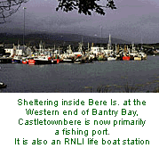
CASTLETOWNBERE 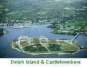 French emigre Jaques Fontaine briefly established a Huguenot settlement near Castletownbere in the early years of the 18th century. Nearby Bere Island was a British naval station until 1938 and there are remains of naval fortifications still there. HEALY PASS 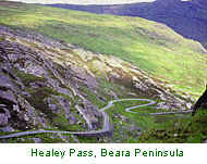 The Healy Pass is a winding mountain road between Adrigole
in Co. Cork and Lauragh in Co. Kerr. Cutting through the high Caha Mountains, the
Healy Pass rises 334 metres above sea level and passes between two of the highest peaks of
the Caha range. This is one of the finest mountain roads in Ireland and is named after Tim
Healy, the first Governor-General of the Irish Free State, who was born in nearby Bantry. The Healy Pass is a winding mountain road between Adrigole
in Co. Cork and Lauragh in Co. Kerr. Cutting through the high Caha Mountains, the
Healy Pass rises 334 metres above sea level and passes between two of the highest peaks of
the Caha range. This is one of the finest mountain roads in Ireland and is named after Tim
Healy, the first Governor-General of the Irish Free State, who was born in nearby Bantry.
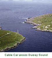
Dursey Island lies off the western extremity of the Beara peninsula and is connected to the mainland by a cable car, the only one in Ireland. The cable car which carries up to six adults, crosses the treacherous waters of Dursey Sound and operates seven days a week. Cork County Council inaugurated the service in 1969.
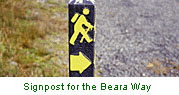
BEARA WAY
|
|
|
Size: A5 (148 x 210 mm) 64 glossy pages (200g/sm) contains over 200 photographs all in splendid colour. Glossy cover with foldout colour map over two pages. Price |
© Earleybird Productions 1998
Email
Website Design: C. Nidecker 1999
Email