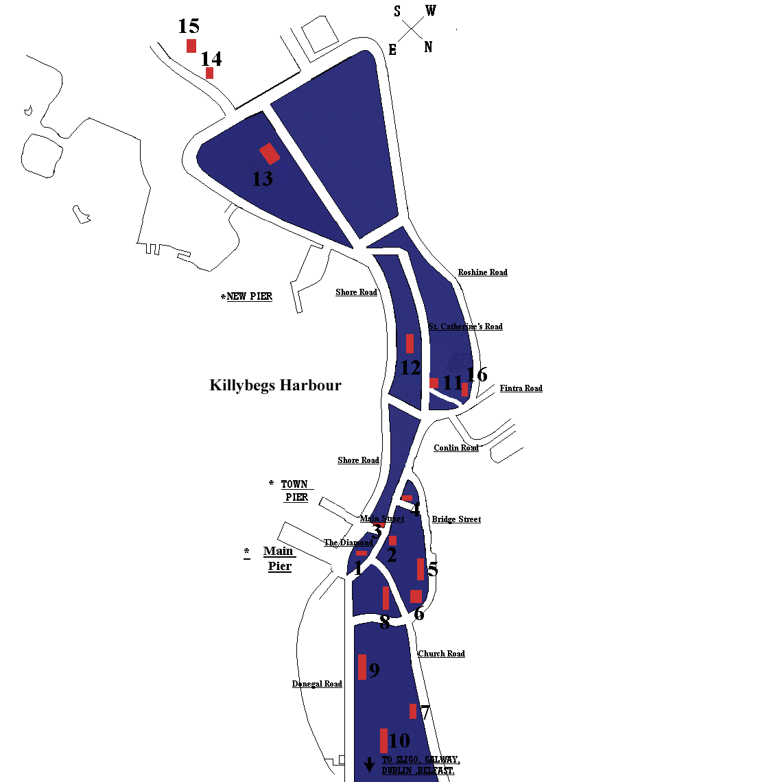
Guided Tour of Killybegs
HISTORY TRAIL
The New Town of Killybegs.The centre of the new town is the Diamond (1), leading to the piers and the waterfront. No original buildings exist in the Diamond area, all having been demolished and replaced. The main landing pier of the 1830's now lies under the street, half way between the Bay View Hotel (2) and the town pier opposite. The first Inn of Killybegs, where the fishermen often bartered over herring, stood on the site of the present Bay View Hotel. Opposite, McGinley's Drapers (3) was erected as a Railway Hotel to cater for the boom in tourism when the railway came to Killybegs in 1893. The private residence next to the Bay View was the home of Captain Alexander Brown, a Coastguard Commander of the 19th century.
The Corn Store. Begin the History Trail by walking "up" Main St. past the Pharmacy to the junction of Main St. and Bridge St. The Public House now known as "Fawlty's" (4) was used as a store for meal during the Great Famine. Indian meal from the floating Depot Ship, Andromeda, anchored in Killybegs Harbour, was stored here for distribution to the hungry people.
Proceed down Bridge St., so named after its bridge which was built in the 1750's. This is one of the oldest parts of Killybegs new town. Continue up Bridge St. and past the Forester's Hall (1910) (5), the Old Niall Mór School (1879) (6) stands at the site of a former R.C. church of the late 18th century.
St. John's Church (C. of I.). Proceeding to Church Rd., and turning left, St. John's Church (7) can be seen on the right. It was commenced in 1825 and was concentrated and dedicated to St. John on June 6th 1828 by William, Bishop of Raphoe. The church is described as "a plain, two bay rendered hall, Y traceried timber windows, west porch supporting a bellcote spire." The building was a straightforward rectangular church until 1860 when the polygonal chancel, designed by Welland and Gillespie, was added. On completion it could hold 200 people.
St. Mary's Church (R.C.). Returning down Church Rd., keep left down Mulreany's Brae, where St. Mary's Church (8) is on the right. According to parish records, the foundation stone was laid on February 2 1842 and it opened to the public 22 months later on Christmas Day 1843. The formal dedication by Dr. Cullen, Archbishop of Dublin, did not take place until August 6th 1854, on account of the Great Famine. Alexander Murray, of Broughton in S.W. Scotland, landlord of Killybegs, had St. Mary's designed by his architect, John Buonarotti Papworth. Murray also provided the site for the church, and gave the single largest donation of £100 towards the building of it. Fr. William Drummond, P.P. and Fr. James Stephens, C.C. were responsible for building St. Mary's. As a Catholic church it is unique in Ireland and still retains its general simplicity of design.
The Murray Lodge. Turning left at the bottom of the brae, the Murray Lodge (9) can be seen further along. It was erected as the Murray Male and Female National Schools in 1860. It was put up at a cost of £1500, at the expense of Horatio Granville Murray Stewart, the main landlord of Killybegs at that time. The Murray Schools opened for the first time on February 1st 1861 and closed in 1926.
The Coastguard Station. Walking past St. Catherine's Vocational School, the former Coastguard Station (10) can be seen on higher ground, on the left. It was erected in 1875 as a modern accommodation block and look-out. The Coastguard's boathouse is located on the sea front below the new road a little way past the Coastguard Station.
Robertson School House. About 100 yards along St. Catherine's Rd. the steep access leading right to New Row is known as Water Lane, because it once led directly to the shore. Next to this lane stands the former Robertson School House (11), erected in 1819 and almost unchanged in appearance since. It now stands as the oldest building erected as a school in Killybegs. It was closed in 1872. A Meeting House for the Methodist Congregation until 1950's.
Bruach na Mara (12). The well preserved Philadelphia town house on the right, headquarters of the Killybegs Fishermen's Organisation, was designed by Savery & Scheetz and built by the Sinnott family in the 1st decade of 20th century. Bishop John Mc Ginley retired here from 1932 until his death in 1969.
Killybegs Tourism College. Further on, turn left on to the Shore Road and the Tourism College (13) can be seen on the right. It was erected in 1896 as a Marine Industrial School, from which the boat building industry began a few years later. During World War II it was used as a barracks for the national army and as a refuge centre for 80 displaced German children at the end of the war. In 1950 it served as a sanatorium for tuberculosis patients.
St. Catherine's Well. Close to St. Catherine's Church is the well (15). There are two views as to the origins of the well, "dedicated to St. Catherine of Alexandria, approximately 6th century" - Rev. Dr. Maguire or "the Norman Invasion brought devotion to St. Catherine in Ireland in 12th century" - Cardinal Moran.
St. Catherine's Church. Continue along Shore Rd. and turn left at the sign for St. Catherine's Well. The remains of St. Catherine's Church (14) can be seen. It was built by Roger Jones, post 1615, and was used as a burial ground for both Catholic & Protestant. The last parish internment was in 1902. Some World War II victims are buried here.
Donegal Carpets. Turn left on to Roshine Rd. & continue back towards the town, the carpet factory (16) is on your right at the junction with the Kilcar/Carrick Rd. It was built by the Congested District Board to alleviate poverty. In 1898 the Scottish firm of Alexander Morton set up their hand knotted carpet factory. These carpets grace some of the most luxurious homes & buildings in the world