The Lough Mask Regional Water Supply Scheme, in design concept, extends treated water from Lough Mask to two principal supply areas in Co. Mayo namely the Castlebar region and to a majority of the South and East Mayo catchment area. Raw water is pumped from the shores of Lough Mask to a high level Treatment Works at Tourmakeady from where it is fed gravitationally to the supply areas.
The construction of the Scheme has been on going in stages since 1979.
Stage I involved construction of the Intake and Pumping Station at Lough Mask, the Rising Mains and High Level Treatment Works at Tourmakeady and the Arterial Main first to Partry and Northwards to Castlebar.
Stage II involved extending the Arterial Main Southwards from Partry to Ballinrobe with storage and control facilities being provided at the Ballinrobe Water Towers. The scheme involved the further extension of the Arterial Main from Ballinrobe to Claremorris with a Service Reservoir and Control Facilities provided at Brookhill near Claremorris.
The Arterial Main servicing each of these areas is under high pressure and has been designed throughout to deliver water at average rates of drawoff rather than peak demand rates. Thus each Town or Group Scheme served must include storage facilities for the following reasons:
To balance local demand peaks,
To act as a contingency supply in the event of an Arterial Main burst,
To break pressure from the Arterial Main to local pressure conditions.
Pipelines and Distribution Watermains
All pipelines were constructed in predominantly Class K9 Ductile Iron with a cement mortar lining and bitumen coated exterior, wrapped in polyethylene.
Service Reservoir
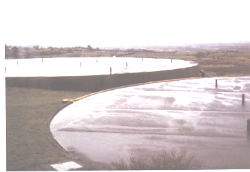
A Service Reservoir of 10,000 cu.m capacity has been constructed
on elevated ground at Brookhill, Claremorris, with an overall
diameter of 50.5 m and a side-wall depth of 5 m.
A Control House has also been constructed adjacent to the Brookhill Reservoir. All of the control valves are housed in the sub-structure of this building which can be controlled either manually or electrically. Flow measurement facilities and chlorine residual monitoring facilities are provided in order to determine the rate of chlorine dosing which also takes place within the Control House. An Office/Telemetry Room is also provided within the Control House at Brookhill which houses all of the electrical control facilities and a Telemetry Outstation.
Water Demands
The total estimated water requirement of the overall region i.e. Claremorris, Barnacarroll, Knock, Ballyhaunis, Ballindine and rural areas between these towns and villages is estimated as 13,187 m3 per day. Overall estimated water usage can be broken down as follows:
Urban and Rural Areas 4,280m3/d Domestic Requirements
Industrial and Commercial Usage 4,150m3/d Claremorris/Ballyhaunis
Agricultural Usage 4,757m3/d
Archaeology
Following topsoil removal, six areas along the pipeline route produced features and small finds of archaeological importance. These included the remains of four Fulachta Fiadha Bronze Age (2,000 500 BC) cooking sites, a stone scatter and a major Early Bronze Age settlement site. All sites were excavated under licence issued from the Department of Arts Culture and the Gaeltacht.
Over six hundred stone artefacts made of mainly chert, flint and limestone were recovered from over a 600 m stretch along the watermain route in the townlands of Leedaun and Millbrook 2km south of Claremorris. Stone scrapers, flakes, blades and a fragment of a polished mud stone axe head were also uncovered. A large gray charcoal enriched soil, a wide curved trench, a concentration of stakeholes and a hearth site all represent successive constructions of flimsy huts which had been burnt. A radio-carbon date of cal. B.B. 2121 1750 was produced from this site.
![]()
![]()