CARNAUN NATIONAL SCHOOL
 ATHENRY A BRIEF HISTORY However
it is only with the coming of the Anglo Normans in the late 12th
century that medieval Athenry really began to exist as a town. In
1178 the title Baron of Athenry was created for Piers de Bermingham making
it the primary Baronacy of Ireland well before 1235 when Richard de Burgo
of Connacht granted a charter to Meiler de Bermingham, 2nd Baron
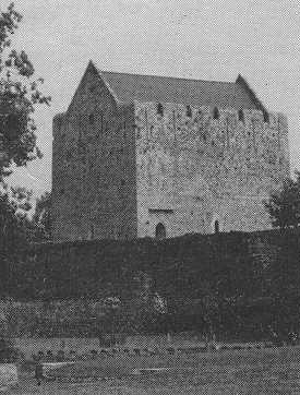
of Athenry, who founded the actual town. Meiler de Bermingham built
the Castle overlooking the ford, a fine town
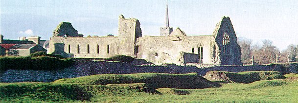
with a market square, a parish church and a few years later the Dominican
Priory of SS. Peter and Paul. That the ford was important
to the Irish also was perhaps to be seen from what is the earliest history
reference to the town - namely the attack by the O'Connors in 1249 when
the Irish were beaten by the Norman cavalry.
To learn more about Athenry Castle
Click Here
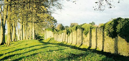
Athenry Town Walls are easily the finest medieval town walls surviving
in Ireland. They enclose 28 hectares (69 acres) thus putting Medieval
Athenry into the top group of Irish walled towns regarding size.
Six of its wall towers and one of its five main gates also survive.
To learn more about the Priory Click
Here
Normally in Ireland Dominican Priories were built just outside the town wall but the Athenry Priory while on the opposite side of the river from the rest of the town was encompassed by the walls. The native Irish co-operated with the Normans in its construction. It was raised to the stature of University in 1644 about the time of the confederation of Kilkenny. Disaster befell when in 1652 Cromwell's soldiers wrecked the building. In 1698 it was formally closed by the Penal Laws. In the mid 18th century the cloister buildings were demolished and it was turned into a barracks for a regiment of English soldiers and was occupied by troops or militia until the R.I.C. Barracks were built in Cross Street. In 1892 it was taken into state care as National Monument No. 164.
In a recent lecture entitled "Unique Athenry", Professor Etienne Rynne,
Professor of Archaeology in University College Galway said:
"People ought to come to visit Athenry because of the features that make the town not interesting or important but In various ways absolutely unique".
The whole town was unique he said. It is a medieval town, almost
totally within its own walls. It has a Castle,
a Dominican Priory, an ancient Parish Church,
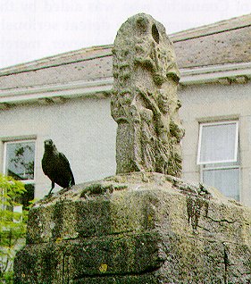
a Market Cross on the square and Town
Walls all dating back to medieval times and, in fact, dating back mostly
to the 14th century, what was most obvious to those coming into the town,
was the spire of the marvellous St. Mary's Church - one of the finest spires
in Ireland in many ways. The walls were unique in that they covered
a larger area than any other town walls in Ireland and that there were
more of them surviving. Certain details within the castle were unique
especially features of the door and two windows which were not to be found
in any other castle in Ireland. Details of the town
gate including an opening for a portcullis and a "murder hole" were
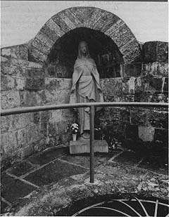
unique. In the Dominican Priory was the greatest collection of medieval
grave slabs in Ireland and the only tomb of its type in Ireland over the
probable grave of Meiler de Berrningham.
Click here to learn more about the Market
Cross
Also, in the mid 19th century the revival of the town started with the coming of railway. This brought much prosperity to the town and surrounding area until its closure as a main railway junction in 1976. However it is still the main Dublin to Galway Line and with the advent of Westrail local steam train excursions to and from Galway and the recent use of the north south line by the Forestry Dept. there is still hope. Agriculturally Athenry became a leader in the 1960s with one of Ireland's major Co-op Marts being set up there and with its "Creamery" which is now a major part of Mid-West Co-operative Group. Modern industries include Byrne Mech., M.J. Quinn, Fahy Engineering and Brody Engineering all of which are light engineering plants. We also have Coffey Construction, Athenry Crystal and C & F Tooling. Mellowes College Athenry and Teagase have also played a major role in the development of the agricultural business in Athenry. The local Credit Union, which since its beginnings in 1966 has grown enormously. Its present share assets of 18 million indicate the growing confidence of the Athenry Community in the town's future.
Confidence in the future can also be seen in the provision of education
for the youth of the parish, now a major industry in its own right.
All the national and second level schools have been rebuilt or renovated
and these coupled with the Teagasc Resource Centre provide the youth of
Athenry with a high standard of education. Over the years local voluntary
organisations have endeavoured to improve the quality of life of the parish.
These vary from the Agricultural Show Society (107 years old) to the Vincent
de Paul Society, Community Care, Community Games, G.A.A. and, more recently,
very successful organisations such as The Project Society, The Women's
Group, The Festival Committee, The Tidy Towns Committee, The Heritage Company
and, of course, The Athenry Parish Development Steering Committee, which
is well on its way to co-ordinating the ideals and strengths of the parish.
Compiled for The Athenry Parish Development
Steering Committee by Finbarr O'Regan 1995
SCOIL NÁISIÚNTA CARNÁIN |