Special Interest

                Vital Statistics
                       ü  2.7 miles*1.7 miles (4.3 km*2.7 km)
 
                      ü  84 inhabitants
                       ü  highest point: 629 ft (192 m)
                       ü  3.4 miles (5.5 km) of road and tracks
                       ü  9 miles (14.5 km) from Clare Island

                       ü  9 miles (14.5 km) from Inishbofin
                       ü  8.5 miles (13.7 km) from Roonagh Quay, Co. Mayo
                       ü  11 miles (17.7 km) from Cleggan, Co. Galway
               Archaeology/History

                         Inishturk

ü  Three earthen forts (or Dúns) situated on the southern shore: one is a promontory fort, on the eastern tip of the cove, Ooghmore. The other two are less intact and are located nearby.
ü  Stone slabs at the foot of the easternmost fort, Dún Ballycraggy
ü A possible standing stone of slate at the east of the church
ü An old church site dedicated to St Columba in the graveyard
ü A Napoleonic signal tower, on top of the highest point of the island (629 ft). The towers of Clare Island and Cleggan Head are visible from this point.


                          Caher Island

Caher Island lies 3 miles (4.8 km) to the east of Inishturk. It is one of the west coast holy islands and is still the site of an annual pilgrimage on the 15th of August. There is a 5th century monastic settlement, probably founded by St Patrick.
ü A small medieval stone oratory
ü A rectangular drystone wall or cashel
ü A holy well on the western point of the island


               Geology

Four blocks of high ground are separated by fault lines running in a general north-south direction. These faults form the main valleys of the island.
A series of ridges and shallow valleys run in an east-west direction. These are parallel to the main axis of folding of a series of sediments which are now in an upright attitude. The softer rocks have eroded faster giving the ridge and valley topography now seen on the island.
Many of the coves, or "Ooghs" are steep sided and show beautiful sections through these folded sediments.


               Natural Heritage

The whole island is a National Heritage Area of national and european importance from a botanical and ornothological point of view.

                           Flora

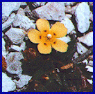
Spotted-Rock rose

The cliff flora is of international importance. The occurence of the slatage-sward vegetation is a contributing factor. But, more specifically, Inishturk is the most northerly recorded location for the wildflower, Spotted-Rock rose (or Tuberaria Guttata). It is a very local and rare vascular plant. The Spotted-Rock rose likes open maritime heath, a threatened habitat. It flowers from April to August.
The interior of the island is covered in  low heath, in which many flowers, woodrushes, sedges and various bedstraws can be found.


                         Birds

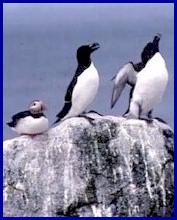
An atlantic Puffin and two Razorbills Ornithology enthusiasts will be enthralled by the number of bird sanctuaries on the island. Guillemot, Puffin, Razorbill, Storm Petrel, Manx, Shearwater, Peregrine Falcon, Kestrel, Chough, Raven, Rock Dove, colonies of Shag, Gulls and Terns abound.
Winter sees the return of the Brent and Baranacle Geese, while nesting waders include Curlew, Lapwing, Ringed Plover, Oystercatcher, Sandpipper, Mallard and Shelduck.

Go to the Top