
|
Archaeological Remains Near Louisburgh |
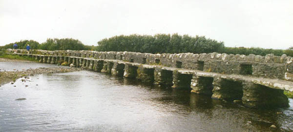
The old "Clapper Bridge" at the Colony, near Cross. See "Cross" for description.
Photo above courtesy of Jim Riding, whose grandfather-in-law came from Roonagh.
The Louisburgh area is extremely rich in archaeological remains. Most of these listed have not previously been recorded and no scientific excavation has been carried out. The areas of greatest concentration are Killeen and Askillaun.
Grid references, where given, relate to Ordnance Survey Map of Ireland No. 10 - 1/2 inch to the mile. Directions given relate to Louisburgh town bridge. Asterisks denote the more interesting monuments.
ASKILLAUN (Right turn past town bridge, 2 miles west)
1. Children’s Burial Ground. Opposite Gill’s house. L772 810.
2. Blessed Well nearby, once a pilgrimage centre, called Cill Bride.
*3 Large Stone Alignment. (Opposite Ball-Alley 200 yards North of No. 2) Probably part of an ancient megalithic tomb. It now consists of ten huge stones in V formation. Known locally as Clocha Fionna.
4. Two Ring Forts (One west of No. 2 near Kelly’s L765 812; the other east of it near McCormack’s L782 812). These forts, often associated in the popular imagination with "the little people", were the surrounding walls of old Celtic homesteads and were commonly used as a protection more against animals than men in the period 500 B.C. — 1600 A.D.
5. Stone Alignment an unusual slab stone called "The Coffin Stone" on hillside past McCormack’s house. L780 810.
DOUGHMAKEON (3 miles south of town, sign post marks Doughmakeon Strand).
*1. CROSS-Inscribed Pillar. A standing stone with encircled Maltese Cross and recorded by Macalister to have borne Ogham inscriptions. The stone is now partially sunk in the sand dunes south of end of the road to the beach (L755 785). It originally stood 8 feet high. Those Ogham pillars were inscribed with the names of a person and his ancestors. The Ogham alphabet consisted of a notch or notches which when grouped together on either side or across the edge of a stone, formed the inscription. They were common from about 300 A.D. to 700 A.D. The letters deciphered by Macalister were 0 V I M A 0.
2. Lough Cahasy nearby was once a centre of pilgrimage. Folklore also associated it with the placing of a curse on enemies. In the sand-hills at Doughmakeon, despite erosion, some middens or rubbish heaps denoting very ancient settlement can still be found.
KILLEEN (Five miles south of town near church. L760 785).
*1. Standing Stone with inscribed Celtic Cross, in Killeen cemetery opposite Church. Those standing stones though bearing Christian symbols, may have been pagan monuments originally, or as some scholars think, merely boundary marks or commemorative stones.
*2. Ancient Slab also in cemetery, placed over grave of Father David Lyons. It bears five crosses, one single line Latin cross with forked ends and a pear-shaped base, an extra shaft below this, probably a representation of a chalice. On each side is a smaller cross of the same shape, and in each upper quarter a small Greek cross. It also bears the Greek letters Alpha and Omega.
CROSS (Right turn past Killeen Church).
1. Clapper Footbridge (200 yards north of junction on sand road L755 760). This is one of the best monuments in the area. It consists of 37 arches constructed in the primitive clapper style, made of flat slabs laid across piles of stones. Date unknown. Called locally "Colony Bridge". (See photo above)
2. Old Churchyard 100 yards north of the Clapper Footbridge, called the "Colony Church" which once catered for a small "colony" of Protestants who lived here.
3. Sinn Féin Dance Hall. An old decayed thatched building near the Bridge was once used as a Volunteer meeting place and dance hall.
4. Standing Stone called Stacamore ½ mile south of bridge near sea 1747 780. Stands over 10 feet high.
KILLADOON AREA
1. Four Standing Stones. The largest is beside Killadoon National School (1750 749); others right turn past Post Office, a smaller one past Morrison’s shop and another right turn past Killary Lodge.
2. Two Forts. One beside Killadoon School; another on left road ½ mile south of this.
3. Old Church at Gowlaun. (One mile south west of Killeen Church 1750 727) 19th century Catholic Church disused after large-scale eviction of tenants in this area.
*4. AiIlemore Court Cairn (Left turn past Killeen Church, then right to grass road over hill, through gate and on right L765 742). Associated, as all over Ireland, with the story of Diarmaid and Gráinne. Called locally "Leaba Dhiarmada". These court-cairns, consisting basically of a ceremonial forecourt and an inner chamber, are amongst the earliest Irish megalithic tombs, erected as communal graves by some of the first farmers in the country. Probably date from 3000 B.C.
5. Children’s Burial Ground. These:were formerly used for unbaptised infants. One on hill side at Feenune near above. Also remains of a wedge-gallery grave nearby.
THALLABAWN AREA
1. Two Forts, one on right past Killary Lodge, on left of sand road; the other in Gallagher’s field on left near Silver Strand.
*2, Primitive Church and Cemetary called Teampall Duch More. A large earthen mound in the middle of the strand at Thallabawn, 20 feet high and 30 feet across. The graves are being constantly eroded. The last burial here was during the First World War. 1738 718.
3. Standing Stone (At left of road near Silver Strand, L765 688) with fine raised cross.
CREGGANBAWN AREA
*1. Wedge-Gallery Grave at Althore. (Opposite lake on road from Killeen to Cregganbawn, 1795 745). Consists of a chamber 8 feet by 5 feet with a cover of 7 feet by 6 feet. A second line of slab stones can be seen at each side. These were the last of Ireland’s megalithic tombs to be built. Erected as communal burial places probably around 2000 to 1500 BC. The name "Althore" suggests that it may have been used as a Mass Rock where Mass was celebrated during times of religious persecution.
2. Blessed Well nearby was once a place of popular devotion. (Tober na hAltóra).
3. Standing Stone at Doirriagh ½ mile south of Cregganbawn cross-roads.
4. Dolmen-like structure called locally Cloch an lompair at Creggánacapall ½ mile north of crossroads near Kilcoyne’s is probably a natural formation called a glacial erratic. (L812 755).
TOWN ENVIRONS
1. Grainne Uaile’s Castle. One of the many castles of Grace O’Maliey, at Caher (1 m. sough of town on right of road to.Killadoon L795 795). Only the foundations and scattered stones now remain. Grace, (d. 1600 A.D.) was the chieftain of the sea-faring O’Malleys in their stormy resistance to the forces of the Queen Elizabeth 1.
2. Court-Cairn at Furmoyle (1 m. further south near Duffy’s. L780 780). Only a small part remains.
3. Souterrain at Collacoon in Ruddy’s field. Now closed. L810 798.
4. Famine Graves. Graves of people buried hastily after death by famine about 1848, at Carramore. (1 mile west of town L780 810).
5. Mass Rock, at Leagan, 1 mile north east of town.
6. Kilgeever Abbey (3 miles east of town turn right, past new cemetery. L838 809). Unroofed church dates from 12th or 13th century, possibly built on the site of a much earlier Patrician Church. People still come here to do the traditional "stations" consisting of a recognized set of prayers at the Church and the nearby B[essed Well in honour of St. Patrick, the National Apostle, who visited here about 460 A.D.
MURRISK — LECANVEY
1. Murrisk Abbey (6 miles east of Louisburgh, road opposite Campbell’s. L920 820). This is the only monument of all those listed here which has been taken over as a National Monument. This was an Augustinian Friary founded in 1457 by Chief Tadgh O’MalIey. It has a fine East window, interesting parapets and a tower, all executed in beautiful stonework. Members of the Prendergast family (Tommy Lannon's) of Accony are buried here, including the three brothers John Joe, Mike and Ritchie, all of whom died in the second half of the twentieth century.
*2. Croagh Patrick (Ascent begins at Campbell’s in Murrisk L920 820). The ascent of this mountain (2,510 feet) with its traditional "stations" has been a penitential exercise for practically 1,500 years since St. Patrick, according to tradition, fasted on its summit for 40 days. The largest annual pilgrimage takes place on the last Sunday in July. In pre-Christian times, the mountain was also a special place, probably because of its unique conical shape and prominence on the landscape of Mayo.
3. Emancipation Cross (at Lecanvey, 200 yards north of road L890 820). These crosses were erected to celebrate The Catholic Emancipation Act 1829.
4. St. Patrick’s Well at Furgail (first turn left driving west from Lecanvey, 3 miles south, L848 782, 200 yards west of Mortimer’s house, surrounded by trees). A stone near the well under a tree with a deep depression is piously believed to be the trace of St. Patrick’s knee. A mound of stones 50 yards east near fence is believed to have been constructed as an altar.
5. Children’s Burial Ground. The numerous little grave stones in the area mark the graves of unbaptised infants. The last burial there took place about 1940. Three forts can be seen on the ridge opposite.
ACKNOWLEDGEMENTS:
We gratefully acknowledge the work of Louisburgh Tourist Association who produced the original pamphlet from which the majority of the information was copied. Original contributors were: Major Aldridge, Ballina; Mr. D. McGreal, Louisburgh; Messrs. Alec and Donald Wallace, Old Head; Dr. Joseph Raftery, National Museum; Dr. Michael Herity, U.C.D.; Dr. Peter Harbison, Bord Failte (Irish Tourist Board); Mrs. E. Philbin, Louisburgh.
FOR FURTHER INFORMATION:
An Choinneal - Louisburgh Parish Magazine.
O’Riordan, Sean P - Antiquities of the Irish Countryside Methuen 1943.
Irish Antiquities; General Guide. Office of Public Works (Dublin).
The course of Irish History. Edited by T. W. Moody and F. X. Martin.
Tales of the West of Ireland, James Berry. Edited by Gertrude Horgan Dolmen Press 1966.